Makalidurga Hill offers a splendid trekking option for people staying in Bangalore over the weekend. Away from the concrete jungle which Bangalore has now converted in to; trekking offers a unique option to get away from this jungle and have a peaceful time on a hill top and enjoy nature.
Though there are quite a few trekking options around Bangalore, but Makalidurga trek is going to be something special for everyone.
The Makalidurga Trek
The first major charm of Makalidurga Hills is the location itself. Makalidurga is located quite near to the city which is well connected through road and rail. Frequent buses are available from Bangalore since it’s a popular trekking destination for the beginners.
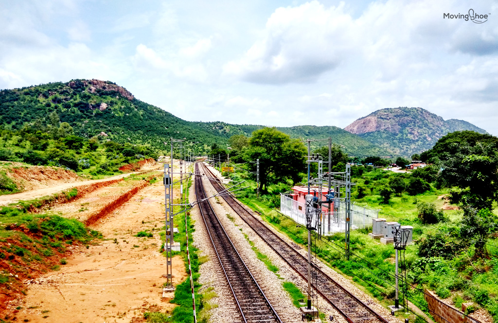
View of the Makalidurga Railway Station, the point from where you will start trekking
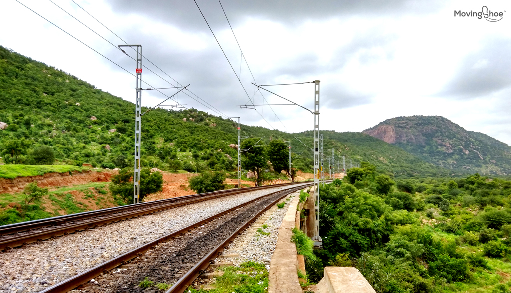
Makalidurga railway station is the starting point of your challenging journey. Unless other trekking destinations in India, Makalidurga offers you a trek through railway tracks.
For me this was the highlight of the trek. From the railway platform, start walking in opposite direction from the highway. From my childhood, I enjoyed walking through the tracks.
Makalidurga trek gives you an opportunity to walk through tracks till you reach the trek base. You need to keep looking for the board ‘54/400’. This is the key and from this milestone you have to take left.
But, before you reach to this board, you actually have to walk around 2.5KMs through the tracks. You will surely enjoy the walk through the tracks. While walking, you can enjoy the beautiful hills standing tall on your left.
View while you walk through the tracks
On you right you can observe the valleys, highway and hills at a distance. If you are in a group, I’m sure you will enjoy clicking several pictures in this 2.5KM stretch.
Once, you reach the 54/400 board, take left and walk for around 200 meters to reach a temple.
A walk through the foothills
A small walk through the valleys downhill just provides you an introduction of the trek that you are going to enjoy in the later course of the time. From, the temple, you can observe a path going towards the hills through right. Keep walking through this path. Depending upon the time you reach, you can observe locals making their cattle graze on the hills.
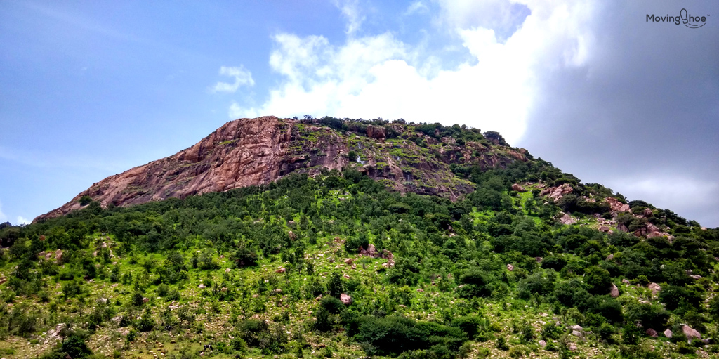
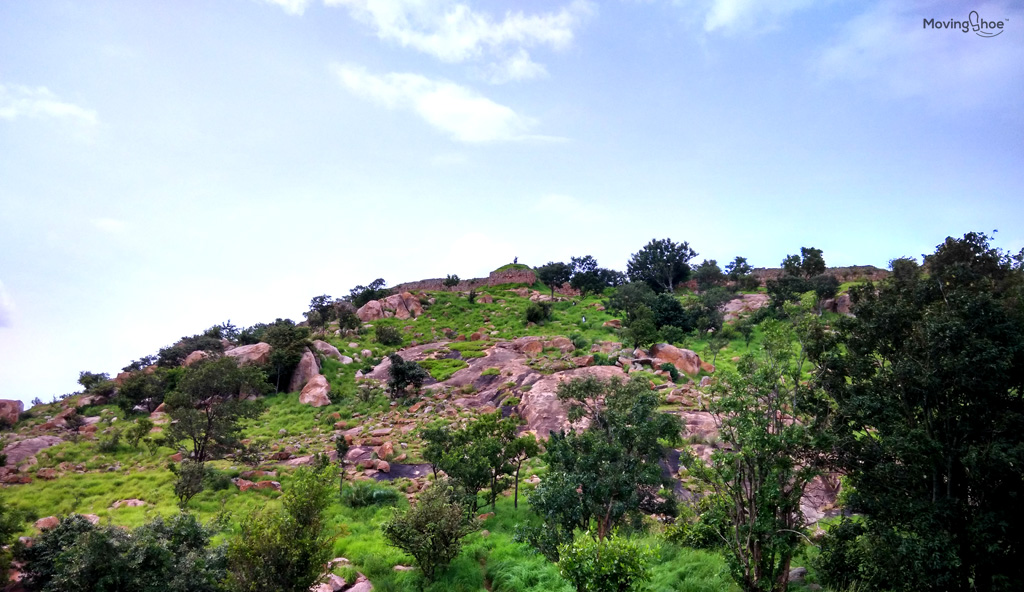
Mighty Makalidurga Hills as it looks from the base
You need to walk for around 300 meters and then take right. Locals available at the sight will definitely help you, as finding this right turn is little challenging. Once, you find this turn, the trek becomes easier. But, the walk in this valley is really enthralling.
The path is in between two hills and you can observe the sharp elevations of the hills and the greeneries associated. The rocky formations are the typical Karnataka hill design, which you can observe here as well. Observing Makalidurga hill from the base looks really challenging, and encouraging at the same time.
The perfect trekking option for beginners
Makalidurga trek is special because of the marked directions.This might not be an encouraging fact for pro trekkers, but for beginners, the marked directions at frequent intervals, are blessing.
The major challenge for a trek is losing your way. This happens very frequently and it results in loss of time and energy. These marked directions will make sure that you reach the top of the hill and enjoy the breathtaking views from there.
The trek is relatively easy for all age group people except at one point where you have to climb a big rock to reach the fort, which could be crossed easily with help of others. But, make sure you wear sports shoes with good sole conditions to avoid any minor accidents.
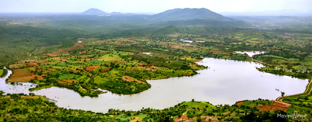
Spectacular view of Gundamagere Lake
You are surely going to enjoy the effort and struggle spent to reach the viewpoint of Gudamagere Lake once you enjoy the view from there. This view is absolutely spectacular and the highlight of the trek.
This lake looks like a South American continent map and looks very pleasing. The view point provides a fantastic opportunity to click some wallpaper images. Around the lake, you can observe paddy fields and the view of the village. Towards the left of the lake, you can see the hills and greenery.
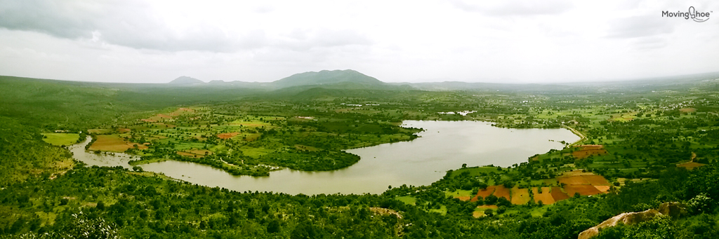
Panaramic View of Gundamagere Lake
The view really takes away your tiredness and you can sit at this point, relax and enjoy the scenic beauty that this place has to offer. Henceforth, this point, the trek becomes little difficult, as you will be required to walk through big stones and steep elevation.
This can be very slippery if you are trekking immediately after rain. I was lucky, that I found the trek route dry and was able to climb up my way to the fort.
The challenging trek to the hill top
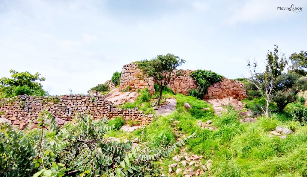
The final destination of the trek is the fort at the hilltop.This 1350 meters (above sea level) trek ends with the ruined fort at top.
But, it takes some level of fitness and determination to reach the fort. Like I mentioned, the trek becomes tougher after the view point.
Adding on to the challenge is the abundance of lemon grasses, which might block you vision and you, can end up stepping in an unstable rock and suffer some minor accidents.
 The trek route till the fort on top
Tip here is to measure your step and make sure you have landed yourself on a stable platform before you take the next steps. You will also have to face some plants with thorns in this stretch.
So, its advisable to focus on the trek to reach the top rather than on clicking pictures. The elevation here becomes steeper than what you have trekked till now and offers a nice little challenge to conquer. But, after all these struggle, the first view of the fort at the top will make you feel accomplished.
Here comes the Fort, here comes the hilltop
Makalidurga is one of those hills which offer 360 degrees views from the top. This awesome view made Makalidurga trek popular among hikers in India.Standing in top of the fort will really give you the feel of accomplishing a trek and the inner satisfaction which you get just indescribable.
 First view of the fort
Makalidurga’s history can be traced back to Vijayanagara Empire where they used to conduct army exercises in this place. The place was later captured by Shahaji and later by Kempegowda.
The ruins of the fort can give you an idea of how the fort would had been looked like on the days of its glory. You can walk around the hills and see the breathtaking views from the top. Also, at top, you can find the temple of Makalidrga which seems to be under operation.
From the hill top it’s spectacular to observe the lakes on either side, curvy roads, village setup, paddy fields and the railway track below the hill. The views of the other mountains are also very pleasing to eyes.
The fort doesn’t seem to be big enough, but it is mostly in ruined conditions. You can just sit here relax and enjoy the cool breeze at the top.
It provides ample opportunities to click pictures and catch hold of your breathe for the trek back to the base.
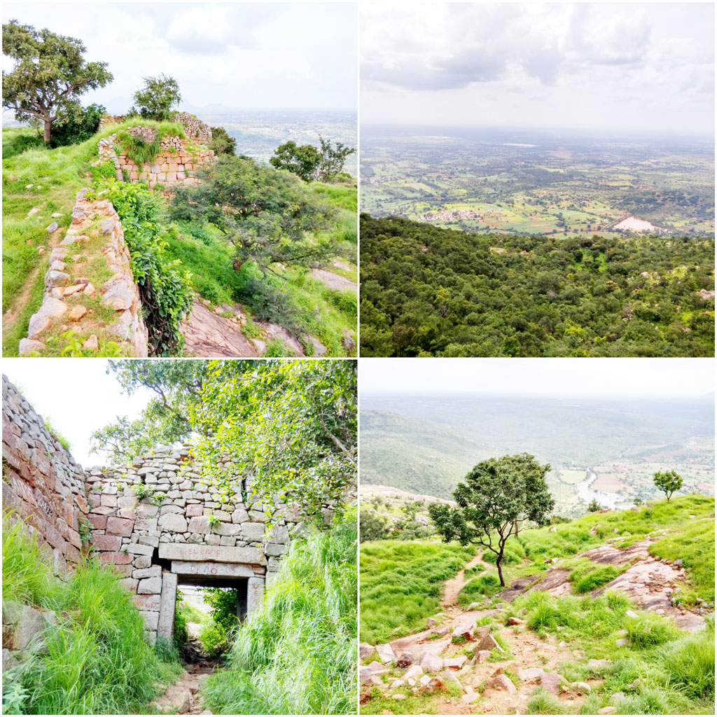
Views from the hill top
I took the same path for trekking back to the base. Remember to look for the signs else you can lose your way quite easily. I had lost my way twice while trekking back.
So, if you are not observing the marks for some time, be assured you are heading in the wrong direction.
How to reach Makalidurga
Being around 60KM from the Bangalore city, you can choose to reach this place by a bicycle or two-wheeler. Of course, 4-wheeler will be the most comfortable option, but I would recommend visiting this place on a two wheeler to enjoy the ride through smooth roads and sceneries around.
The road conditions are quite good, except in few patches. You need to take the Bangalore-Hyderabad highway and continue till you see the board mentioning Doddaballapura (left 20KM). I’m sure you are not going to miss this mile board.
From this board, take left towards Doddaballapura and continue driving straight. You can really enjoy driving in this stretch as the roads are good with least possible traffic and surrounded by paddy fields, hills tree plantations. This road will take you to the Doddaballapur town.
After the Railway Crossing, you will reach the roundabout. You are just required to go straight. From this roundabout you have to ride further 10-15KMs to reach the small bridge, underneath, you can see your destination: The Makalidurga Railway Station.
Before your Makalidurga trek
Carry ample water with you as the trek will drain your energy. Trekking back till the view point is little challenging due to the sharp elevations, but form the view point it’s easier.That’s the reason, why many don’t complete the full Makalidurga trek and return back from the view point.
A pair of shoe with good traction and water proof body will be a good companion for you.ensure that the shoes are not old or new, get used to the shoe if it is new. You will be walking for atleast 4hrs to complete the Makalidurga trek